 Lýsigagnagátt

Type of resources
Available actions
Topics
INSPIRE themes
Keywords
Contact for the resource
Provided by
Years
Formats
Representation types
Update frequencies
status
Service types
Scale
Resolution
-
Vinsamlega hafið samband við Hagstofuna vegna nánari upplýsinga.
-

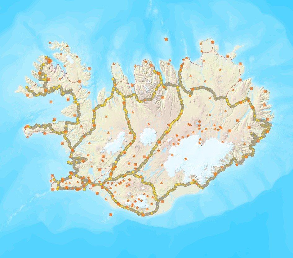
[IS] Í Rammasjá er hægt að skoða gögn sem tengjast áætlun um vernd og orkunýtingu landsvæða, þ.e.a.s. Rammaáætlun. [EN] The Master Plan for Nature Protection and Energy Utilization Map
-
Þekja (layer) n25v_leirur_fl: Leirur á Íslandi. (Mudflats.) Leirur njóta sérstakrar verndar samkvæmt 61 gr. í lögum um náttúruvernd. Náttúrufræðistofnun Íslands heldur skrá yfir þessi náttúrufyrirbæri og birtir í kortasjá sem jafnframt er viðauki við náttúruminjaskrá.
-
Skoðunarþjónustur Náttúrufræðistofnunar
-
Vinsamlega hafið samband við Fiskistofu vegna nánari upplýsinga.
-
Þann 16. mars 2011 gáfu Náttúrufræðistofnun út í fyrsta sinn sameiginlegt hæðarkerfi fyrir Ísland. Kerfið er kallað Landshæðarkerfi Íslands og er viðmiðunin ISH2004. Tilkoma sameiginlegs hæðarkerfis markaði stór tímamót í sögu landmælinga á Íslandi. Á sama hátt og viðmiðunin ISN93 skapaði grundvöll fyrir alla til að vinna í sama hnitakerfi mun ISH2004 skapa grundvöll fyrir alla til að vinna í sama hæðarkerfi. Eitt samræmt hæðarkerfi er mikilvægt fyrir ýmsar framkvæmdir s.s. vegagerð og jarðgangnagerð og á ýmsum sviðum umhverfisvöktunar, skipulags og áætlanagerðar. Auk þess munu gögnin nýtast við rannsóknir á jarðskorpuhreyfingum eða breytingum á yfirborði sjávar. Mælingar á Landshæðarkerfinu eru standa ennþá yfir og frá fyrstu útgáfu þess árið 2011 hafa bæst við eftirfarandi línur hallamælilínur. • Flókalundur-Bolungavík • Reykjavík-Keflavík • Endurmæling á Suðurlandi vegna jarðskjálftans 2008 • Hellisheiði • Reykjanesbraut-Grindavík • Þjóðvegur 1-Akranes • Kjölur Niðurstöður nýrra mælinga verður bætt inn í þetta gagnasett um leið og þær liggja fyrir.
-
Vinsamlega hafið samband við Hafrannsóknastofnun vegna nánanri upplýsinga.
-

Íslenskum skipum eru bannaðar veiðar með botnvörpu, flotvörpu og dragnót í fiskveiðilandhelgi Íslands nema á þeim veiðisvæðum og veiðitímum sem tilgreind eru í 5. grein laga nr. 79 um veiðar í fiskveiðilandhelgi Íslands. Viðmiðunarlínan er dregin umhverfis landið á milli punkta sem eru taldir upp í lagagreininni. Vinsamlega hafið samband við Landhelgisgæslu Íslands vegna nánari upplýsinga.
-

Í gögnunum er að finna upplýsingar um staðsetningu og umfang verndarsvæða í byggð sem ráðherra hefur staðfest í samræmi við lög nr. 87/2015 um verndarsvæði í byggð. Markmið laganna er að stuðla að varpveislu og vernd byggðar sem hefur sögulegt gildi.
-
Þekja (layer) j100v_austurland_gigar_1utg_li: Útlínur öskjurima útkulnaðra megineldsstöðva. [Outlines of calderas of extinct volcanos.] Útlínur miða við höggun, dreifingu þursabergs og móbergsmyndana. [The lines are based on local tectonics, distribution of agglomerates and hyaloclastites.]