 Lýsigagnagátt
ESRI Shapefile
Type of resources
Available actions
Topics
INSPIRE themes
Keywords
Contact for the resource
Provided by
Years
Formats
Representation types
Update frequencies
status
Scale
Resolution
-
Íslandi er skipt upp í loftgæðasvæði og bera heilbrigðiseftirlit viðkomandi svæða ábyrgð á því að ekki sé farið yfir mörk þar, og áætlunum um hvernig bregðast á við ef farið er yfir mörk.
-
Vinsamlega hafið samband við Umhverfisstofnun vegna nánari upplýsinga.
-

Gögnin sýna svæði þar sem refaveiði er óheimil allt árið um kring.
-

Vinsamlega hafið samband við Umhverfisstofnun vegna nánari upplýsinga.
-
Ramsarsvæði eru votlendissvæði í heiminum sem njóta sérstakrar verndar.
-
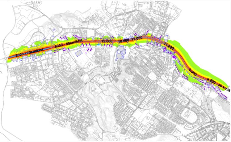
Hávaðakort fyrir vegi og þéttbýlissvæði má sjá hér fyrir neðan. Einnig greinagerðir fyrir hvert sveitarfélag fyrir sig sem fjalla meðal annars um niðurstöður mælinga og útreikninga, fjölda íbúa sem verða fyrir hávaða og hljóðvarnir. Miðað er við að hávaði frá vegum, við húsvegg fyrir íbúðarhúsnæði á íbúðar-, verslunar-, þjónustu- og miðsvæðum, fari ekki yfir 55-65 dB LAeq24 (meðaltalsgildi hávaða yfir einn sólarhring).
-
Fráveituvatn er í eðli sínu notað vatn. Vatn sem við höfum nýtt til að baða okkur, elda mat, sturta niður í klósettin, þvo bíla, föt og ýmislegt annað. Notkunin veldur því að allskonar efni s.s. úrgangur frá fólki, matarleifar, olíur, sápur, hreinsiefni, málmar og jafnvel hættuleg efni blandast í annars hreint vatn. - Fráveituvatn getur verið mengunarvaldur en góð hreinsun getur dregið verulega úr neikvæðum áhrifum þess: - Úrgangur frá fólki er saurmengaður lífrænn úrgangur sem inniheldur bæði áburðarefni og mikið magn örvera og sýkla. - Í fráveituna berst ýmis úrgangur t.d. af yfirborði gatna og rusl (blautklútar, tannþráður o.fl.) sem er hent í í salerni. - Ýmis hættuleg efni s.s. úr hreinsiefnum, eldtefjandi efni og skordýraeitur geta fundist í fráveituvatni. - Mikið magn af næringarefnum (fosfór og köfnunarefni) í skólpi getur valdið ofauðgun eða aukinni framleiðslu þörunga (þörungablóma) sem getur leitt til skorts á súrefni í vatninu. Slíkt hefur neikvæð áhrif á staðbundið vatnalíf og getur valdið dauða ýmissa lífvera. - Fráveituvatn mengað af lyfjaleifum getur haft neikvæð áhrif á dýr, eins og fjölgun og hegðun þeirra. Losun sýklalyfja í skólpi eykur þróun lyfjaónæmis hjá bakteríum í umhverfinu. Best er að draga eins og hægt er úr allri efnanotkun og sturta ekki efnum í klósett og niðurföll heldur fara með þau til móttökuaðila slíks úrgangs.
-
Skyndilokanir Upplýsingar um skyndilokanir veiðisvæða koma úr gagnagrunnum Fiskistofu. Frá árinu 2020 hefur ákvörðunartaka um skyndilokanir veiðisvæða fyrir tilteknum veiðum verið í höndum Fiskistofu en var áður hjá Hafrannsóknarstofnun. Skyndilokun varir að jafnaði í 2 vikur. Tímamörk lokunar eru alltaf tilgreind með ákvörðun skyndilokunar. Ákvörðun um skyndilokun veiðisvæðis er gerð þegar mælingar á afla stenst ekki viðmiðunarmörk Hafrannsóknarstofnunar en einnig til að loka svæðum sem hafa staðbundinn kvóta. Reglugerðalokanir Reglugerðir eru ákvarðaðar af Atvinnuvega- og nýsköpunarráðuneytinu (ANR) og skilgreina bannsvæði og tímabil, þar sem fiskveiðar eru bannaðar með tilteknum veiðarfærum. Sumar reglugerðarlokanir eru árstíðarbundnar, til dæmis friðun vegna hrygninga þar sem svæðum sem fiskur kemur til hrygninga er lokað á ákveðnum tíma ársins.
-

The Urban Atlas provides pan-European comparable land use and land cover data for Functional Urban Areas (FUA). The Street Tree Layer (STL) is a separate layer from the Urban Atlas 2012 LU/LC layer produced within the level 1 urban mask for each FUA. It includes contiguous rows or a patches of trees covering 500 m² or more and with a minimum width of 10 meter over "Artificial surfaces" (nomenclature class 1) inside FUA (i.e. rows of trees along the road network outside urban areas or forest adjacent to urban areas should not be included). Urban Atlas is a joint initiative of the European Commission Directorate-General for Regional and Urban Policy and the Directorate-General for Enterprise and Industry in the frame of the EU Copernicus programme, with the support of the European Space Agency and the European Environment Agency.
-
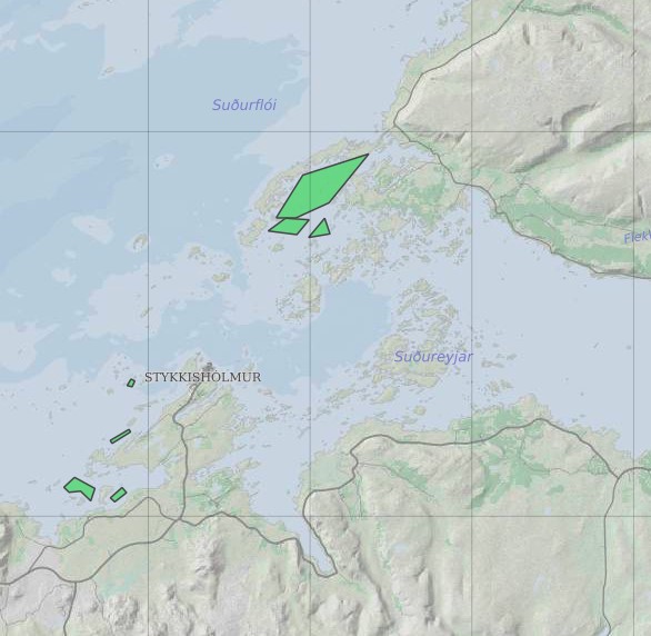
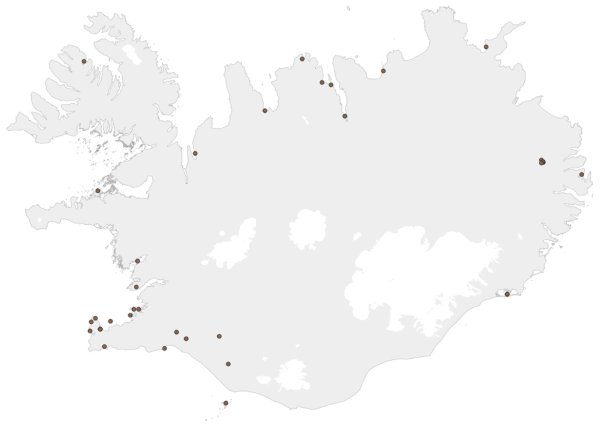
Ræktunarsvæði er afmarkað svæði sjávar nægjanlega stórt til að rúma þann ræktunarbúnað sem notaður er á viðkomandi svæði. Yfirleitt er um að ræða línur sem strekktar eru á milli flot bauja eða sérstaka ræktunarfleka með lóðréttar ræktunarlínur fáeina metra niður undir yfirborð sjávar . Svæðið er merkt með löglegum sjómerkjum þannig að sjófarendur eiga að geta varast þau, enda einnig merkt inn sjókort Landhelgisgæslunnar. Einungis er ræktuð Bláskel (Kræklingur).