 Lýsigagnagátt
boundaries
Type of resources
Available actions
Topics
INSPIRE themes
Keywords
Contact for the resource
Provided by
Years
Formats
Representation types
Update frequencies
status
Scale
Resolution
-
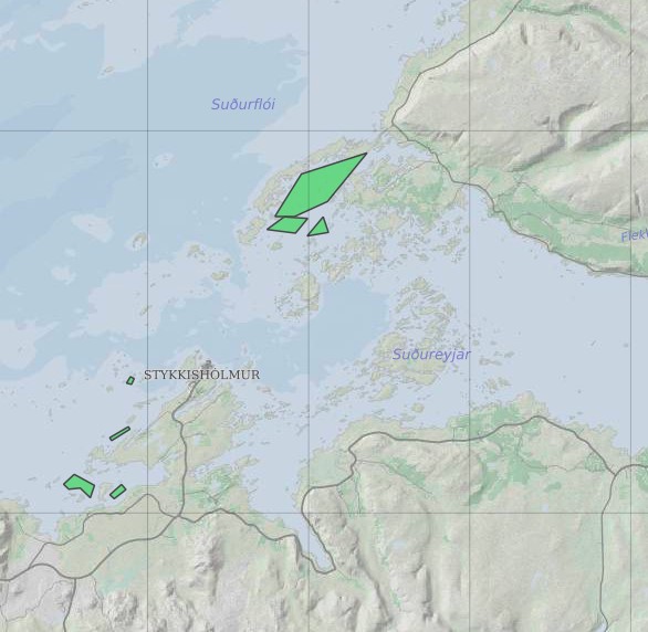
Ræktunarsvæði er afmarkað svæði sjávar nægjanlega stórt til að rúma þann ræktunarbúnað sem notaður er á viðkomandi svæði. Yfirleitt er um að ræða línur sem strekktar eru á milli flot bauja eða sérstaka ræktunarfleka með lóðréttar ræktunarlínur fáeina metra niður undir yfirborð sjávar . Svæðið er merkt með löglegum sjómerkjum þannig að sjófarendur eiga að geta varast þau, enda einnig merkt inn sjókort Landhelgisgæslunnar. Einungis er ræktuð Bláskel (Kræklingur).
-

The combined Water and Wetness product is a thematic product showing the occurrence of water and wet surfaces over the period from 2009 to 2015. Two products are available: o The main Water and Wetness (WAW) product with defined classes of (1) permanent water, (2) temporary water, (3) permanent wetness and (4) temporary wetness. o The additional expert product: Water & Wetness Probability Index (WWPI) The products show the occurrence of water and indicate the degree of wetness in a physical sense, assessed independently of the actual vegetation cover and are thus not limited to a specific land cover class and their relative frequencies. A verification of the Water and Wetness layer was performed by the Institute of Nature Research during autumn of 2018 and the data and resulting report are made available on the NLSI websites.
-

The main high resolution grassland product is the Grassland layer, a grassland/non-grassland mask for the EEA39 area. This grassy and non-woody vegetation baseline product includes all kinds of grasslands: managed grassland, semi-natural grassland and natural grassy vegetation. It is a binary status layer mapping grassland and all non-grassland areas in 20m and (aggregated) 100m pixel size. Two additional (expert) products complete the high resolution grassland product: the Ploughing Indicator (PLOUGH) and the Grassland Vegetation Probability Index (GRAVPI). While the PLOUGH concentrates on historic land cover features with the aim to indicate ploughing activities in preceding years, the GRAVPI provides a measure of classification reliability. GRAVPI is a 20m pixel size product, mapping on a range of 1-100 the class probability. PLOUGH is a 20m pixel size additional product, mapping from 1-6 the number of years since the last indication of ploughing. A verification of the Grassland layer was performed by the Institute of Nature Research during autumn of 2018 and the data and resulting report are made available on the NLSI websites.
-

Línurnar sýna friðunarsvæði, þar sem eldi laxfiska (fam. salmonidae) í sjókvíum er óheimilt skv. auglýsingu nr. 460/2004.
-

Þekjan sýnir orkuspársvæði sem koma fram í orkuspá Orkustofnunar. Það eru svæðin Suðurnes, Reykjavík, Vesturland, Vestfirðir, Norðurland, Austurland og Suðurland. Svæðin eru aðeins öðruvísi en í hefðbundinni landshlutaskiptingu þar sem sú skipting er til komin vegna uppbyggingar flutningskerfisins.
-

Eftirfarandi landshlutar eru sóttvarnaumdæmi, sbr. reglugerð 387/2015: Höfuðborgarsvæðið (Reykjavíkurborg, Seltjarnarnesbær, Kópavogsbær, Garðabær, Hafnarfjarðarkaupstaður, Mosfellsbær, Kjósarhreppur og fyrrum sveitarfélagið Þingvallasveit). Vesturland (Akraneskaupstaður, Hvalfjarðarsveit, Skorradalshreppur, Borgarbyggð, Eyja- og Miklaholtshreppur, Snæfellsbær, Grundarfjarðarbær, Helgafellssveit, Stykkishólmsbær, Dalabyggð, Reykhólahreppur, Strandabyggð, Kaldrananeshreppur, Árneshreppur og Húnaþing vestra). Vestfirðir (Vesturbyggð, Tálknafjarðarhreppur, Ísafjarðarbær, Bolungarvíkurkaupstaður og Súðavíkurhreppur). Norðurland (Húnavatnshreppur, Blönduósbær, Skagabyggð, Sveitarfélagið Skagaströnd, Sveitarfélagið Skagafjörður, Akrahreppur, Fjallabyggð, Dalvíkurbyggð, Hörgársveit, Eyjafjarðarsveit, Akureyrarkaupstaður, Svalbarðsstrandarhreppur, Grýtubakkahreppur, Þingeyjarsveit, Norðurþing, Tjörneshreppur, Skútustaðahreppur, Svalbarðshreppur og Langanesbyggð að frátöldum fyrrum Skeggjastaðahreppi). Austurland (Vopnafjarðarhreppur, Fljótsdalshérað, Fljótsdalshreppur, Borgarfjarðarhreppur, Seyðisfjarðarkaupstaður, Fjarðabyggð, Breiðdalshreppur, Djúpavogshreppur og fyrrum Skeggjastaðahreppur). Suðurland (Sveitarfélagið Ölfus, Hveragerðisbær, Grímsnes- og Grafningshreppur, Bláskógabyggð að frátöldu fyrrum sveitarfélaginu Þingvallasveit, Hrunamannahreppur, Sveitarfélagið Árborg, Flóahreppur, Ásahreppur, Skeiða- og Gnúpverjahreppur, Rangárþing ytra, Rangárþing eystra, Mýrdalshreppur, Skaftárhreppur, Sveitarfélagið Hornafjörður og Vestmannaeyjabær). Suðurnes (Sandgerðisbær, Sveitarfélagið Garður, Reykjanesbær, Grindavíkurbær og Sveitarfélagið Vogar).
-
Línurnar sýna friðunarsvæði, þar sem eldi laxfiska (fam. salmonidae) í sjókvíum er óheimilt skv. auglýsingu nr. 460/2004.
-

This data includes all defined hiking trails within Vatnajökull National Park, and selected trails near the park. The trails are drawn from hiking maps that the park has published since it was founded in 2008. The maps have been updated regularly since, last update was in 2019, (Snæfell area and a large part of the western region). These hiking maps can be viewed by selecting “Hiking map, click on frame” in the Vatnajökull National Park Mapview, (see link below).
-

Riparian zones represent transitional areas occurring between land and freshwater ecosystems, characterised by distinctive hydrology, soil and biotic conditions and strongly influenced by the stream water. They provide a wide range of riparian functions (e.g. chemical filtration, flood control, bank stabilization, aquatic life and riparian wildlife support, etc.) and ecosystem services. The Riparian Zones products will support the objectives of several European legal acts and policy initiatives, such as the EU Biodiversity Strategy to 2020, the Habitats and Birds Directives and the Water Framework Directive. Land Cover/Land Use (LC/LU) classification is tailored to the needs of biodiversity monitoring in a tailored buffer zone along large and medium-sized European rivers (with Strahler levels 3-8 derived from EU-Hydro). LC/LU is extracted from VHR satellite data and other available data in a buffer zone of selected rivers. The classes follow the pre-defined nomenclature on the basis of MAES typology of ecosystems (Level 1 to Level 4) and Corine Land Cover, providing 80 distinct thematic classes with a Minimum Mapping Unit (MMU) of 0.5 ha and a Minimum Mapping Width (MMW) of 10 m. The production of the Riparian Zones products was coordinated by the European Environment Agency in the frame of the EU Copernicus programme.
-

Gögnin sýna hvar bráðamóttökur, læknavaktir og heilsugæslustöðvar eru staðsettar á landinu. Um er að ræða samstarfsverkefni Embættis landlæknis og heilsugæslunnar á höfuðborgarsvæðinu.