 Lýsigagnagátt
geoscientificInformation
Type of resources
Available actions
Topics
INSPIRE themes
Keywords
Contact for the resource
Provided by
Years
Formats
Representation types
Update frequencies
status
Scale
Resolution
-
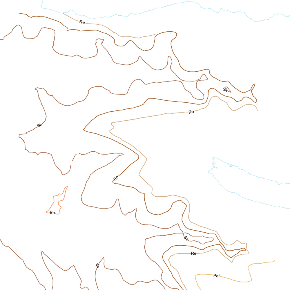
Þekja (layer) j100v_austurland_millilog_1utg_li:: Gjóskulög á Austfjörðum. [Tuff layers in Eastern Iceland.] Línur sýna staðsetningu stærstu gjóskulagana á Austfjörðum. Gjóskulögin eru fengin úr ýmsum kortum og kortlagningu Birgis V. Óskarssonar. Gögn eru flokkuð eftir ÍST120:2012 staðlinum, nema þrjá fitjueigindir: myndunKodi = Heiti myndunarinnar (skammstöfun) myndunIS = Heiti myndunarinnar (á íslenskuc) myndunEN = Heiti myndunarinnart (á ensku) [Lines show the location of largest tuff deposits in Eastern Iceland. The tuff layers are derived from older maps and the mapping of Birgir V. Óskarsson. The data follows the ÍST120:2012 data standard with the three additional feature attributes: myndunKodi = Lithostratigraphic unit (abbreviation) myndunIS = Lithostratigraphic unit (in Icelandic) myndunEN = Lithostratigraphic unit (in English)]
-
Þekja (layer) j100v_austurland_skridur_1utg_li: Lagið sýnir útlínur stærstu framhlaupa á svæðinu. [The layer shows the outlines of the largest landslides of the area.]
-
Þekja [layer] j100v_vesturgosbelti_jardgrunnur_1utg_fl: Jarðgrunnsgögn af Vesturgosbelti Íslands. [Surface deposits of the Western Volcanic Zone of Iceland.] Laus setlög, svo sem jökulgarðar og árset. [Unconsolidated sediments including glacial morianes and river sediments.]
-
Þekja (layer) j100v_austurland_hoggun_1utg_li: Sprungur og misgengi. [Cracks and faults.] Gögn með sprungum og misgengjum kortlögð í ýmsum kortlagningaverkefnum. [Data showing cracks and faults mapped in various mapping projects.]
-
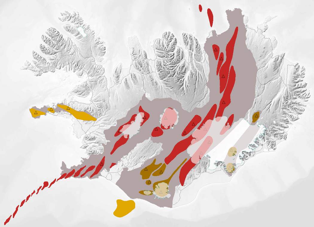
Gagnasafn (GDB) NI_J600v_bergradir_ISN93_1.utg: NI_J600v Bergraðir Íslands – 1:600.000 [NI_J600v Igneous rock series of Iceland – 1:600.000]. Kort af þremur bergröðum Íslands. Kortið sýnir virk gosbelti á Íslandi og landgrunni þess á nútíma og síðjökultíma, virk eldstöðvakerfi á nútíma, útbreiðslu gosstöðva og samsetningu gosbergs (flákalag). Staðsetning megineldstöðva er einnig sýnd (punktalag). Gerður er greinarmunur á þóleiískum, alkalískum og millibergskerfum. [The map of the three igneous rock series of Iceland at a scale of 1:600.000 shows the volcanic zones active in Iceland and its insular shelf during the Holocene and Late Pleistocene, volcanic systems active during the Holocene, the distribution of eruption sites and chemical composition of erupted rocks (polygon layer). The position of central volcanoes is also shown (point layer). Tholeiitic, alkalic and transitional alkalic volcanic systems are differentiated.]
-
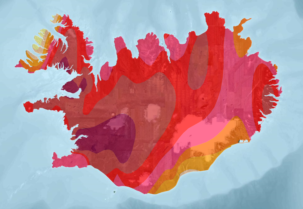
The dataset presents three layers of geothermal data from Iceland based on "Atlas of Geothermal Resources in Europe" (2002). Heat-flow density, Temperature at 1000 meters and Temperature at 2000 meters (1:10 000 000).
-
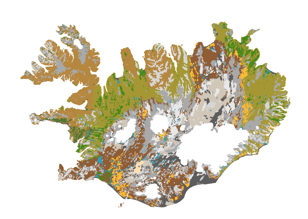
Íslenskur jarðvegur telst til eldfjallajarðar (Andosol) að langmestum hluta, en eldfjallajörð er jarðvegur sem myndast á eldvirkum svæðum heimsins. Eldfjallajörð hefur afar sérstæða eiginleika sem greina hana frá öðrum jarðvegsgerðum. Útbúin var einföld flokkun fyrir íslenskan jarðveg, sem m.a. byggist á alþjóðlegum flokkunarkerfum en einnig á vinnu Björns Jóhannessonar og Þorsteins Guðmundssonar. Flokkunin gerir greinarmun á i) jarðvegi auðna (glerjörð sem skiptist í melajörð, malarjörð, sandjörð og vikurjörð; ii) jarðvegi gróins lands með sortueiginleika (sortujörð, sem skiptist í brúnjörð, votjörð og svartjörð), iii) lífrænni mójörð og að síðustu iv) öðrum jarðvegi sem er margvíslegur að gerð. Í síðasta flokknum er bergjörð útbreiddust, en auk þess má nefna frerajörð sífrerasvæða og kalkjörð. Jarðvegskortið var unnið á grundvelli sniða og jarðvegssýna sem safnað hefur verið víða um landið. Kortið er á vektora formi og í mælikvarða 1:500 000. Það er m.a. hluti evrópska jarðvegskortsins. A soil map of Iceland: The Soil map classification separates between; 1) andic soils, which are Brown Andosols, Gleyic Andosols and Histic Andosols; 2) Vitrisols, soils of deserts, which are divided into Cambic Vitrisols, Gravelly Vitrisols, Arenic Vitrisols and Pumice Vitrisols iii) Histosols, and iv) other soil types such as Cryosols and Leptosols. The classification system is in part based on WRB system and Soil Taxonomy and earlier work by Björn Jóhannesson and Þorsteinn Guðmundsson (see English Summary and 1. table in http://www.moldin.net/uploads/3/9/3/3/39332633/jardvegskort_2.pdf). The map is in a coarse scale (1:500 000) and is not intended to use for particular points on the landscape. It is rather an overview. It has been incorporated into the EU soil database and the Circumpolar soil map.
-
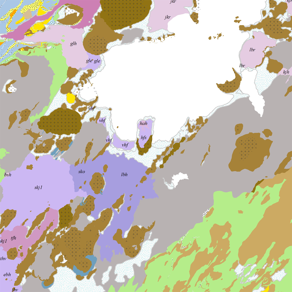
Þekja [layer] j100v_vesturgosbelti_berggrunnur_1utg_fl: Gögn fyrir berggrunn ásamt nútímahraunum. [Data showing the bedrock geology, including Holocene lavas.] Berggrunnur er flokkaður eftir aldri, gerð og samsetningu. Gögn eru flokkuð eftir ÍST120:2012 staðlinum, nema fitjueigindir: myndunKodi = stuttur kóði sem táknar gerð bergmyndunar, myndunIS = stutt íslenskt heiti fyrir bergmyndun, myndunEN = stutt enskt nafn á bergmyndun, eldstodNafn = nafn eldstöðvakerfis, kenni = stuttur kóði fyrir hlýskeiðishraun og nútímahraun, aldur = aldursbil, Nýr kóði fyrir fitjueigindina 'Tegund storkubergs' (tegStorkubergs): dbas = dílabasalt. [Bedrock is classified by age, type, and composition. The data follows the ÍST120:2012 data standard with these additional feature attributes: myndunKodi = short code denoting the rock formation type, myndunIS = short Icelandic name for rock formation, myndunEN = short English name for rock formation, eldstodNafn = name of the volcanic system, kenni = short codename for interglacial and postglacial lavas, aldur = age range. New code for feature attribute 'Tegund storkubergs' (tegStorkubergs): dbas = porphyrytic basalt.]
-

Snjómokstursleiðir eru fyrirfram skilgreindar leiðir á milli ákveðinna staða. Vegagerðin gefur út upplýsingar um færð á þessum leiðum. Hver leið hefur ákveðið þjónustustig og snjómokstursreglur.
-
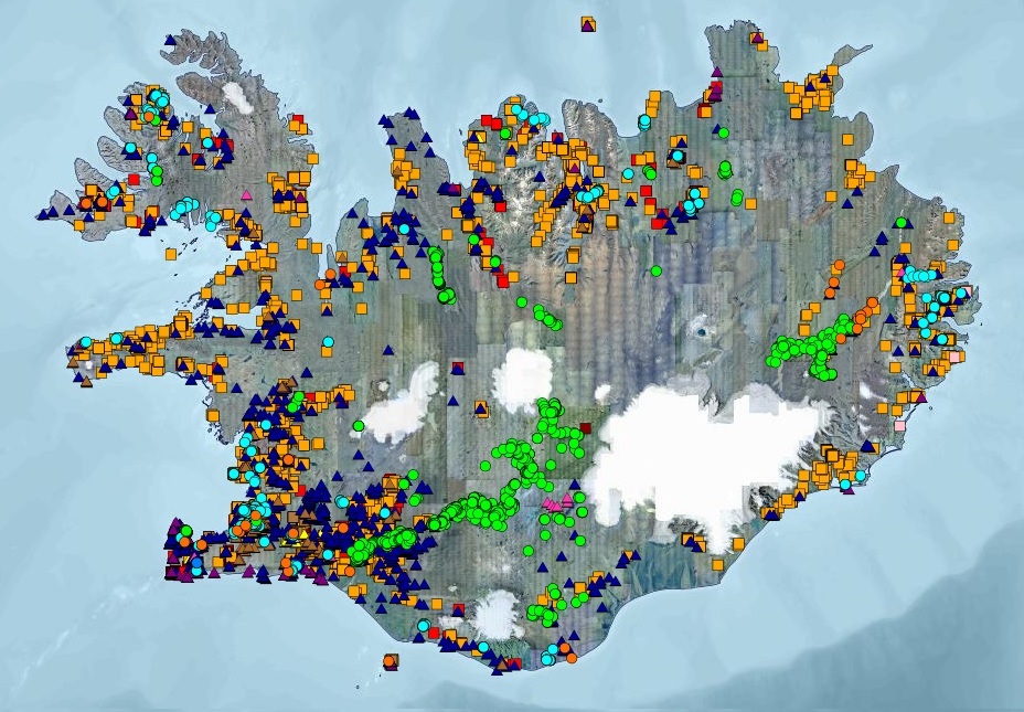
Gagnasett sem sýnir yfirlitsupplýsingar úr Borholugrunni Umhverfis- og orkustofnunar um borholur á Íslandi. Fram koma meðal annars: auðkennisnúmer borholu, borholunafn, staðarheiti, bortími, dýpi, sveitarfélag, eldra hreppsnafn, landnúmer, tilgangur og tegund borunar, bor og borfyrirtæki, staðsetningarhnit í ISN93 og WGS84, gæði hnita, fóðringardýpi og holuvídd. Í töflunni eru yfir 15.000 færslur. Upplýsingar úr gagnatöflunni eru bæði aðgengilegar á vefsíðu UOS og í Kortasjá UOS.