 Lýsigagnagátt
ESRI ArcGIS FileGDB
Type of resources
Available actions
Topics
INSPIRE themes
Keywords
Contact for the resource
Provided by
Years
Formats
Representation types
Update frequencies
status
Scale
-
Gagnasafn (GDB) NI_reit_v_LiflandfraedilegSvaedi_sveppir: Líflandfræðileg svæði fyrir sveppi [Bio-geographical provinces for fungi in Iceland]. Reitakerfið er notað til að sýna grófa útbreiðslu sveppa eftir landshlutum og byggir á 10 km reitakerfi NÍ. Fláka- og línulag.
-
Gagnasafn (GDB) NI_reitakerfi_v: Reitakerfi fyrir útbreiðslukort lífvera á Íslandi í 10 km og 2 km reitum [10-km- and 2-km-grid to compile distribution maps of organisms in Iceland]. Flákalag og punktalag (miðpunktar). Hver reitur er auðkenndur með 4 tölustöfum þannig að tvær fyrstu tölurnar tilgreina lóðrétta dálkinn en tvær síðustu þann lárétta. [Polygons and center points. The tiles are numberd with a 4 digit code, the first 2 digits name the column, the last 2 digits name the row within this grid.]
-
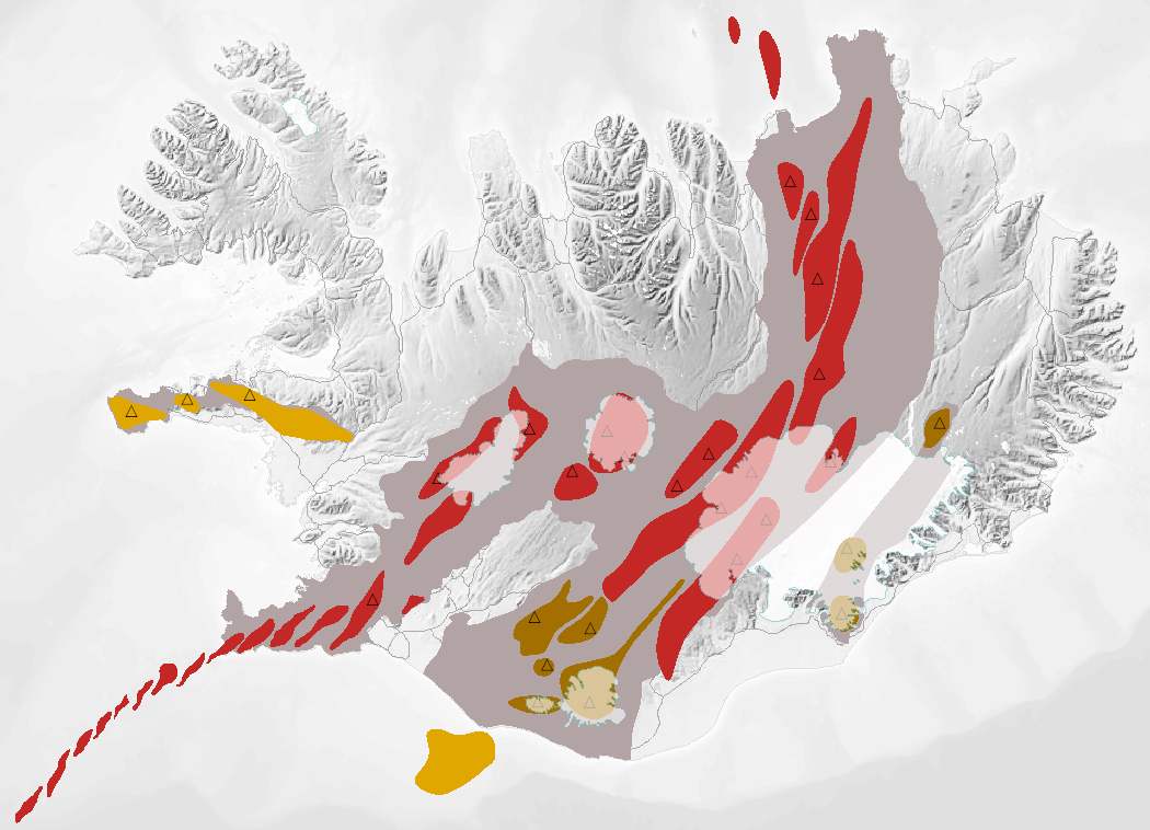
Gagnasafn (GDB) NI_J600v_bergradir_ISN93_1.utg: NI_J600v Bergraðir Íslands – 1:600.000 [NI_J600v Igneous rock series of Iceland – 1:600.000]. Kort af þremur bergröðum Íslands. Kortið sýnir virk gosbelti á Íslandi og landgrunni þess á nútíma og síðjökultíma, virk eldstöðvakerfi á nútíma, útbreiðslu gosstöðva og samsetningu gosbergs (flákalag). Staðsetning megineldstöðva er einnig sýnd (punktalag). Gerður er greinarmunur á þóleiískum, alkalískum og millibergskerfum. [The map of the three igneous rock series of Iceland at a scale of 1:600.000 shows the volcanic zones active in Iceland and its insular shelf during the Holocene and Late Pleistocene, volcanic systems active during the Holocene, the distribution of eruption sites and chemical composition of erupted rocks (polygon layer). The position of central volcanoes is also shown (point layer). Tholeiitic, alkalic and transitional alkalic volcanic systems are differentiated.]
-
Gagnasafn (GDB) NI_D25v_selalaturVidStrendurIslands_2.utg.: Útbreiðsla landsela (Phoca vitulina) og talningagögn 1980-2018. Útbreiðsla útsela (Halichoerus grypus) og talningagögn 1982-2017. [Seal haul-outs around Iceland]. Fjögur flákalög sem sýna kortlagningu 430 landselslátra á 93 talningasvæðum (ni_d25v_landselir_1980_2018_selalatur_fl, ni_d25v_landselir_1980_2018_talningarsvaedi_fl) og 86 útselslátra á 19 talningasvæðum (ni_d25v_utselir_1982_2017_selalautur_fl, ni_d25v_utselir_1982_2017_talningarsvaedi_fl). Talningagögn segja til um fjölda sela á hverju talningasvæði. Selir eru taldir á nokkurra ára fresti og gefur ágæta mynd af breytingum í stofnstærð og umfangi selalátra. Landselir eru taldir síðsumars en útselir að hausti. Nánari skýringar á aðferðum við selatalningar og stofnmat er að finna í Fjölriti 56. Látur eru strandsvæði sem selir leita á til að kæpa, sinna uppeldi kópa, hafa feldskipti og hvílast. Orðið selalátur vísar hér til smæstu samfelldu spildanna þar sem selir halda til. Talningasvæði er aftur á móti víðtækara safnheiti sem oftast nær yfir mörg smærri selalátur. Nákvæmni kortlagningu selalátra miðast við mælikvarða 1:25.000, en nákvæmni talningasvæða er um 1:250.000. [General overview of the seal haul-out locations around Iceland for harbour seals (Phoca vitulina) and grey seals (Halichoerus grypus). The harbour seal population has been monitored with direct counts (aerial censuses) since 1980 and the grey seal population since 1982. Both feature classes 'latur' show the haul-outs (Icelandic: látur) for each species. The haul-outs are grouped into counting zones (Icelandic: talningarsvæði) and both feature classes 'talningarsvaedi' show the associated population counts.] .
-
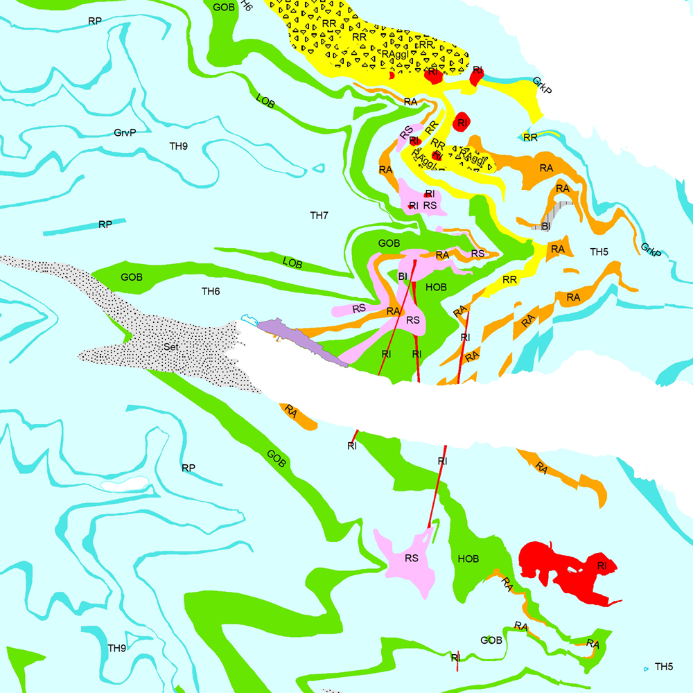
Þekja (layer) j100v_austurland_berggrunnur_1utg_fl: Gögn sem sýnir bergrunn Austurlands. [Data showing the bedrock geology of Eastern Iceland.] Flákalag með bergrunn Austurlands. Flákarnir sýna mismunandi gerðir storkubergs ásamt sethulu. Gögn eru flokkuð eftir ÍST120:2012 staðlinum, nema þrjá fitjueigindir: myndunKodi = Heiti myndunarinnar (skammstöfun) myndunIS = Heiti myndunarinnar (á íslenskuc) myndunEN = Heiti myndunarinnart (á ensku) Nýr kóði fyrir fitjueigindi 'Tegund storkubergs' (tegStorkubergs): shra = samsett hraun, dbas = Dílabasalt, dobas = Díla- og olívínbasalt, and = Andesít. [Polygone layer of the bedrock geology of Eastern Iceland. The polygones show different classes of intrusive and extrusive rocks and the sediment cover. The data follows the ÍST120:2012 data standard with the three additional feature attributes: myndunKodi = Lithostratigraphic unit (abbreviation) myndunIS = Lithostratigraphic unit (in Icelandic) myndunEN = Lithostratigraphic unit (in English) New codes for feature attribute 'Tegund storkubergs' (tegStorkubergs) are: shra = composit lava, dbas = porphyritic lava, dobas = porphyritic and olivine basalt, and = andesite.]
-
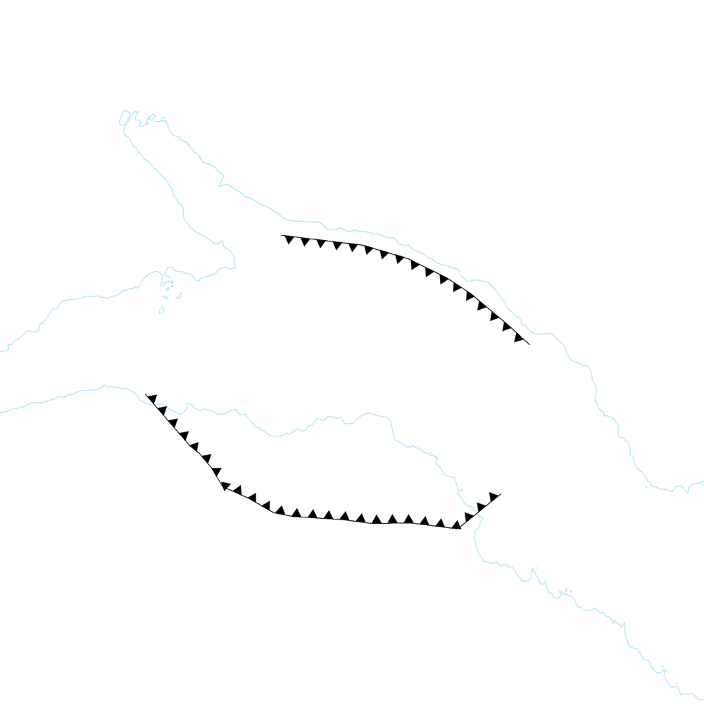
Þekja (layer) j100v_austurland_gigar_1utg_li: Útlínur öskjurima útkulnaðra megineldsstöðva. [Outlines of calderas of extinct volcanos.] Útlínur miða við höggun, dreifingu þursabergs og móbergsmyndana. [The lines are based on local tectonics, distribution of agglomerates and hyaloclastites.]
-
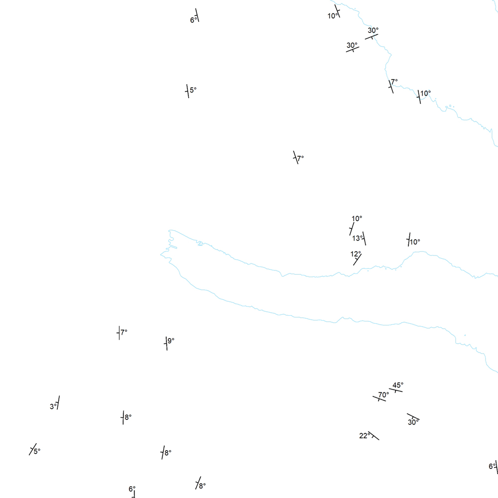
Þekja (layer) j100v_austurland_strikHalli_1utg_p: Strik og hallastefna jarðlaga. [Strike and dip of the deposits.] Staðsetning mælinga á striki og hallastefnu jarðlaga á Austurlandi. [Locations of measurements of strike and dip of the deposits in Eastern Iceland.]
-

Gagnasafn (GDB) NI_J600v_hoggun: Jarðfræðikorti af Íslandi – Höggun – 1:600.000 [Geological Map of Iceland – Tectonics – 1:600.000]. Höggunarkort af Íslandi sýnir jarðfræði landsins á nýstárlegan hátt. Jarðlög eru flokkuð eftir aldri en ekki eftir gerð og samsetningu. Sýnd eru eldstöðvakerfi, þ.e. megineldstöðvar, sprungu- og gangareinar, bæði virkar og útkulnaðar. Einnig eru sýnd helstu brotakerfi landsins og halli jarðlaga. Kortið gefur innsýn í jarðfræðilega byggingu landsins. [The Tectonic Map of Iceland gives a new view of the country's geology. The rocks are classified by age, but not by type or composition. Volcanic systems including central volcanoes, fissures and dyke swarms, both active and extinct, are shown, as are the island's principal fracture zones and the dip of rock layers. The map thus gives a useful insight into the geological structure of the country.]
-
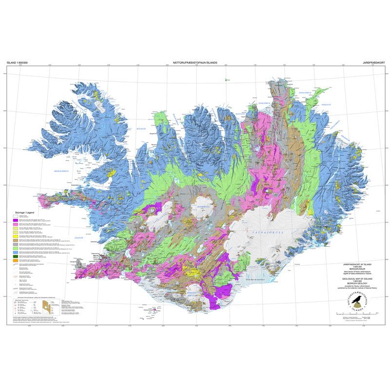
Gagnasafn (GDB) NI_J600v_berg_2.utg: Jarðfræðikorti af Íslandi – Berggrunnur – 1:600.000 [Geological Map of Iceland – Bedrock geology – 1:600.000]. Berggrunnskort af Íslandi sýnir stærstu drættina í jarðfræði landsins. Jarðlög eru flokkuð eftir aldri, gerð og samsetningu. Kortið sýnir vel gosbelti landsins og dreifingu gossstöðva frá nútíma. Nútímahraunum er skipt í forsöguleg og söguleg hraun (yngri en 871 e. Kr. ). [The Geological Map of Iceland shows the main features of the bedrock geology. Formation are classified by age, type, and composition. The map clearly shows the island's volcanic zones and the distribution of the recent eruption sites. Lava fields of the Holocene are shown as pre-historic or historic (younger than AD 871].]
-
Þekja (layer) j100v_austurland_steingervingar_1utg_p: Fundarstaðir steingervinga. [Locations with fossils.] Fundarstaðir steingervinga, einkum plöntusteingervinga eða surtabrands. [Location with fossils, exclusvely plant fossils or lignite deposits.]