 Lýsigagnagátt
Náttúrufræðistofnun – Natural Science Institute of Iceland
Type of resources
Available actions
Topics
INSPIRE themes
Keywords
Contact for the resource
Provided by
Years
Formats
Representation types
Update frequencies
status
Service types
Scale
-
Þekja (layer) j100v_austurland_gigar_1utg_li: Útlínur öskjurima útkulnaðra megineldsstöðva. [Outlines of calderas of extinct volcanos.] Útlínur miða við höggun, dreifingu þursabergs og móbergsmyndana. [The lines are based on local tectonics, distribution of agglomerates and hyaloclastites.]
-
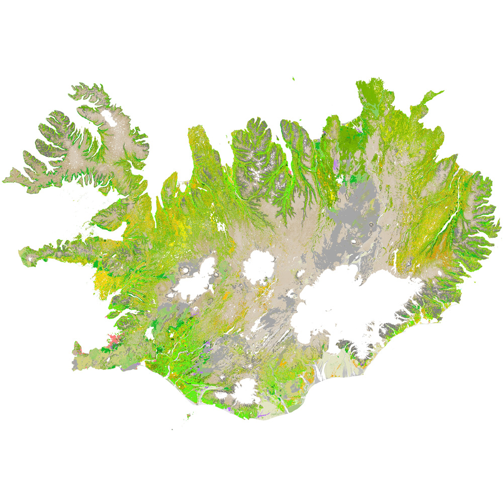
Gagnaset (data set) ni_vg25r_3utg: Vistgerðir á Íslandi: land (Habitat types of Iceland: terrestrial). Vistgerðakortið sýnir útbreiðslu landvistgerða á Íslandi. Alls hafa verið ákvarðaðar 64 vistgerðir á landi og skiptast í 12 meginflokka (vistlendi). Innan landvistgerða eru fjórar jarðhitavistgerðir sem finnast á háhita- og lághitasvæðum landsins. Landvistgerðum er skipt upp í tvö þrep. Við skilgreiningu og flokkun vistgerða á Íslandi var tekið mið af EUNIS-flokkunarkerfinu (European Environment Agency 2012) . Í 3. útgáfu vistgerðakortsins 2024 eru eingöngu landvistgerðir endurskoðaðar. Náttúrufræðistofnun Íslands leggur með ritinu Vistgerðir á Íslandi fram tillögur að flokkun vistgerða sem á sér fyrirmynd í samræmdri og viðurkenndri flokkun vistgerða í Evrópu. Flokkunin byggir á rannsóknum víða um land með fyrirvara um að bæta mætti í þá þekkingu. Athuga skal að aðgreining landvistgerða með fjarkönnun reyndist erfið, bæði fyrir lítið grónar vistgerðir sem og vel grónar, einkum innan vistlenda. Því má búast við verulegum skekkjum þótt þær séu mismiklar eftir vistgerðum. Nánari útlistun og mat á skekkjum má finna í aðferðalýsingu og á staðreyndasíðum vistgerða í ritinu „Vistgerðir á Íslandi“. Frekari upplýsingar um flokkun og skilgreiningu vistgerða má sjá í ritinu: Jón Gunnar Ottósson, Anna Sveinsdóttir og María Harðardóttir, ritstj. 2016. Vistgerðir á Íslandi. Fjölrit Náttúrufræðistofnunar nr. 54. 299 s. og á vef Náttúrufræðistofnunar.
-
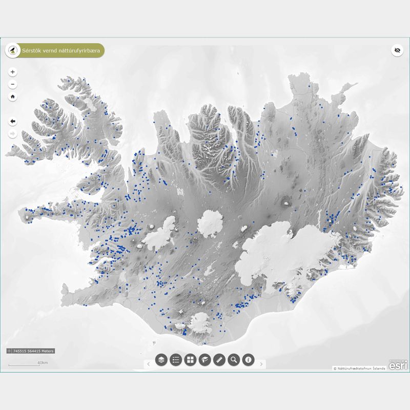
Þekja (layer) n50v_fossar_p: Fossar á Íslandi. (Waterfalls in Iceland.) Fossar og nánasta umhverfi þeirra að því leyti að sýn að þeim spillist ekki, njóta sérstakrar verndar samkvæmt 61 gr. í lögum um náttúruvernd. Náttúrufræðistofnun Íslands heldur skrá yfir þessi náttúrufyrirbæri og birtir í kortasjá sem jafnframt er viðauki við náttúruminjaskrá.
-
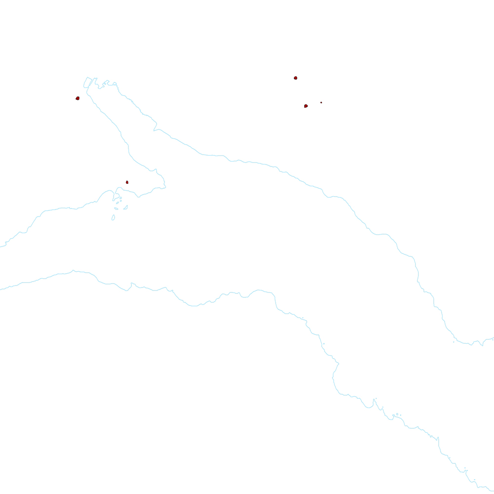
Þekja (layer) j100v_austurland_gigar_1utg_fl: Flákar sem sýna gjallgíga í jarðlagastafla Austurlands. [Polygon data of scoria cones in Eastern Iceland.}
-
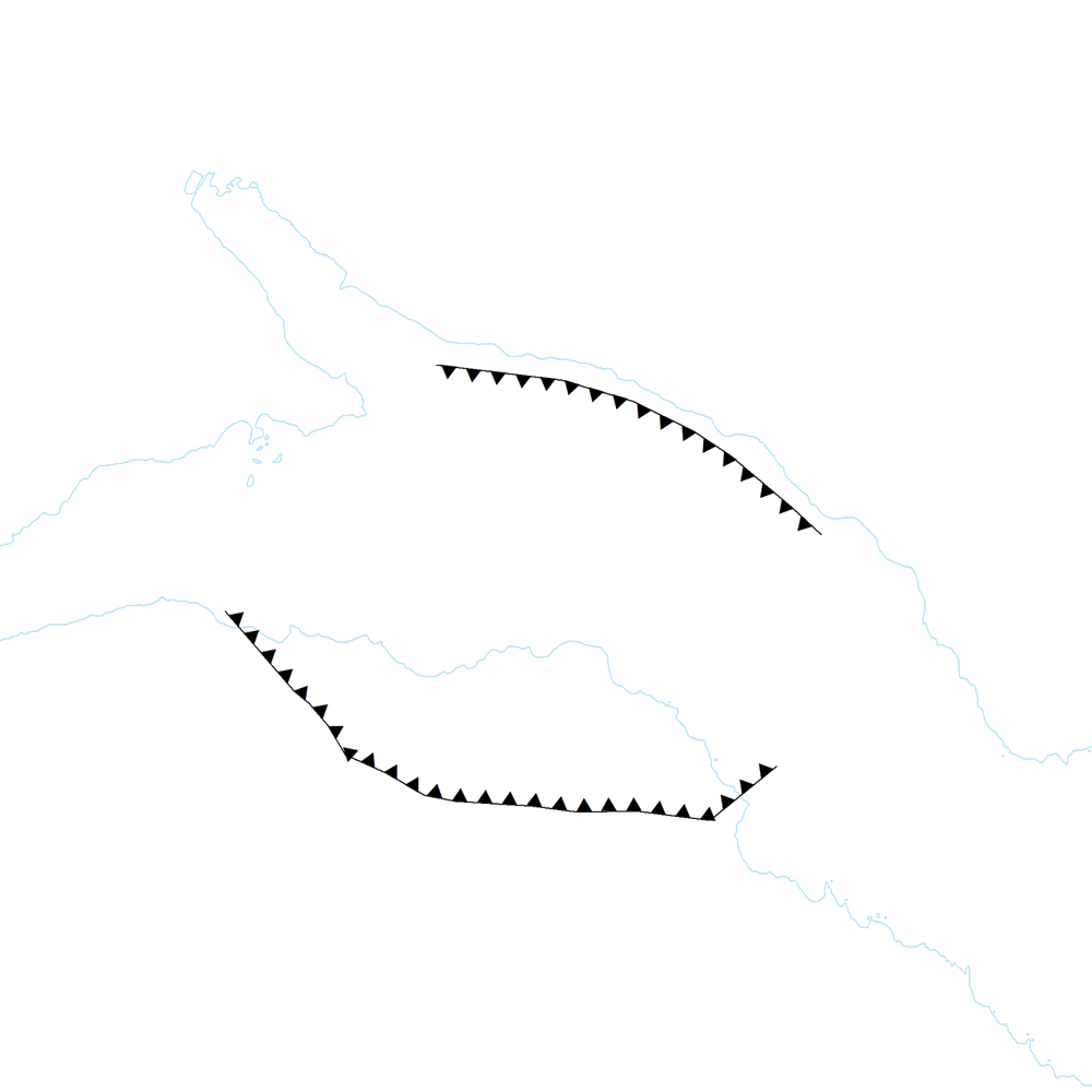
Þekja [layer] j100v_vesturgosbelti_berggrunnurNidurfoll_1utg_fl: Niðurföll í nútímahraunum. [Collapse pits in Holocene lavas.}
-
Þekja ni_tillogur_a_Bhluta_allt_fl: Tillögur að svæðum á framkvæmdaáætlun (B-hluta) náttúruminjaskrár út frá verndun vistgerða, fugla, sela, jarðminja og fossa. Innan stærri verndarsvæða voru í sumum tilfellum afmörkuð smærri svæði sem draga fram forgangsvistgerðir eða fuglategundir sem eru ekki einkennandi fyrir heildarsvæðið. Mörk eru ekki alltaf nákvæmlega skilgreind. Náttúruminjaskrá skiptist í þrjá hluta sem auðkenndir eru sem A, B og C-hluti. B-hluti er framkvæmdaáætlun náttúruminjaskrár þ.e. skrá yfir þær náttúruminjar sem Alþingi hefur ákveðið að setja í forgang um friðlýsingu eða friðun á næstu fimm árum. Í lögunum er lögð áhersla á að byggja upp skipulegt net verndarsvæða til að stuðla að vernd líffræðilegrar fjölbreytni, jarðbreytileika og fjölbreytni landslags. Náttúrufræðistofnun Íslands gerir tillögur um minjar sem ástæða þykir til að setja á framkvæmdaáætlun, þ.e. B-hluta. Að loknu því vali felur ráðherra Umhverfisstofnun að meta nauðsynlegar verndarráðstafanir á svæðum sem til greina kemur að setja á framkvæmdaáætlun og kostnað við þær. Í því ferli koma fram ýmsir aðrir hagsmunir sem geta haft áhrif á endanlegt val svæða en eru sem slíkir ekki grunnþættir í vali á svæðum til að viðhalda ákjósanlegri verndarstöðu vistgerða, vistkerfa eða tegunda. Að lokum mun Umhverfis-, orku- og loftslagsráðuneytið í samráði við ráðgjafanefnd leggja fram þingsályktunartillögu um verndun svæða. Tillögurnar eru enn í úrvinnslu hjá Umhverfisstofnun og umhverfis-, orku- og loftslagsráðherra (staða 23. febrúar 2022). Afmörkun svæða í tillögum Náttúrufræðistofnunar er ekki alltaf nákvæmlega skilgreind og getur tekið breytingum við áframhaldandi undirbúning framkvæmdaáætlunar.
-
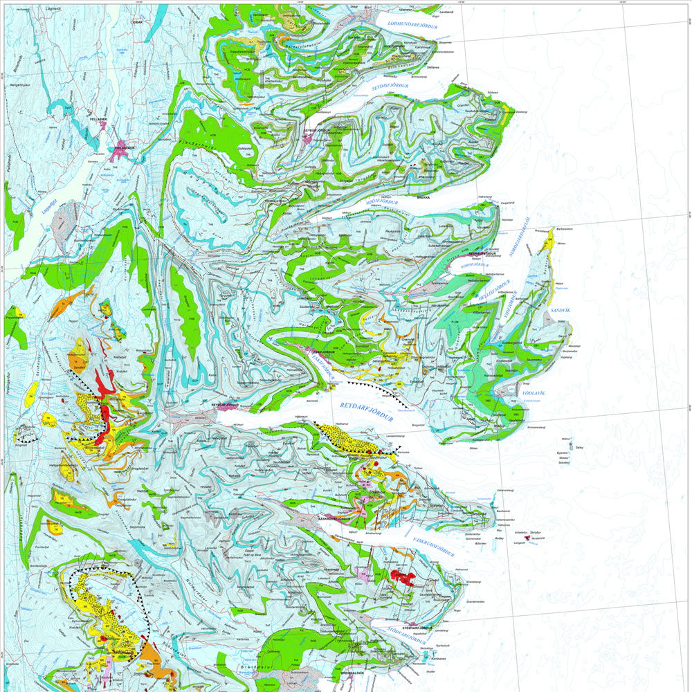
Gagnasafn (GDB) NI_J100v_Austurland_1.utg: Jarðfræðikort af Austurlandi í mælikvarði 1:100.000, 1. útg. [Geological map of Eastern Iceland in the scale of 1:100.000, 1st ed.] Jarðfræðikort af Austurlandi nær yfir svæði frá Berufirði yfir í Mjóafjörð. Berggrunnur er flokkaður eftir gerð og samsetningu. Kortið sýnir túff (gjóskulög), gíga, öskjurima, sprungur, misgengi, strik og halla, framhlaup, steingervinga, lindir og mörk segulskeiðsins C5n. [The Geological map of Eastern Iceland covers the area from Berufjörður up to Mjóifjörður. Bedrock is classified by type and composition. The map shows tuff layers, craters, caldera rims, fissures, faults, strike and dip, landslides, fossils, springs and the base of magnetic chron C5n.]
-

Skoðunarþjónustur Náttúrufræðistofnunar (Jarðfræði, líffræði, náttúruvernd)
-
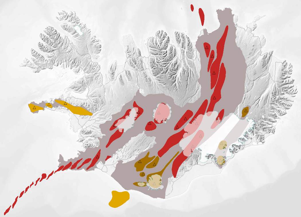
Gagnasafn (GDB) NI_J600v_bergradir_ISN93_1.utg: NI_J600v Bergraðir Íslands – 1:600.000 [NI_J600v Igneous rock series of Iceland – 1:600.000]. Kort af þremur bergröðum Íslands. Kortið sýnir virk gosbelti á Íslandi og landgrunni þess á nútíma og síðjökultíma, virk eldstöðvakerfi á nútíma, útbreiðslu gosstöðva og samsetningu gosbergs (flákalag). Staðsetning megineldstöðva er einnig sýnd (punktalag). Gerður er greinarmunur á þóleiískum, alkalískum og millibergskerfum. [The map of the three igneous rock series of Iceland at a scale of 1:600.000 shows the volcanic zones active in Iceland and its insular shelf during the Holocene and Late Pleistocene, volcanic systems active during the Holocene, the distribution of eruption sites and chemical composition of erupted rocks (polygon layer). The position of central volcanoes is also shown (point layer). Tholeiitic, alkalic and transitional alkalic volcanic systems are differentiated.]
-
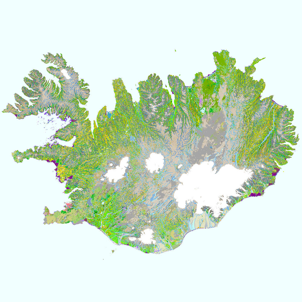
Gagnaset (data set) ni_vg25v_1.1utg og ni_vg25r_3utg: Vistgerðir á Íslandi (Habitat types of Iceland). Vistgerðakortið sýnir útbreiðslu vistgerða á Íslandi. Vistgerðum á Íslandi er skipt upp í land, ferskvatn og fjörur. Alls hafa verið ákvarðaðar 64 vistgerðir á landi, 17 vistgerðir fyrir ferskvatn og 24 vistgerðir fyrir fjörur. Landvistgerðir skiptast í 12 meginflokka (vistlendi). Innan landvistgerða eru fjórar jarðhitavistgerðir sem finnast á háhita- og lághitasvæðum landsins. Land- og ferskvatnsvistgerðir skiptast í tvö þrep, en fjöruvistgerðir í fimm þrep. Við skilgreiningu og flokkun vistgerða á Íslandi var tekið mið af EUNIS-flokkunarkerfinu (European Environment Agency 2012). Landupplýsingaþekjan fyrir landvistgerðir er á rastaformi (ni_vg25r_3utg), en þekjur fyrir jarðhita, ferskvatns- og fjöruvistgerðir er á vektorformi (ni_vg25v_1.1utg). Vektorþekjurnar eru flestar flákaþekjur, en fyrir ferskvatn er einnig línu- og punktaþekja. Gögn fyrir stöðuvötn (vg2 = V1) eru fjarlægð tímabundið úr niðurhalsþjónustu vegna ágreinings um grunnkort Loftmynda ehf. en þekjan er sýnileg í kortasjá. Náttúrufræðistofnun Íslands leggur með ritinu Vistgerðir á Íslandi fram tillögur að flokkun vistgerða sem á sér fyrirmynd í samræmdri og viðurkenndri flokkun vistgerða í Evrópu. Flokkunin byggir á rannsóknum víða um land með fyrirvara um að bæta mætti í þá þekkingu. Athuga skal að aðgreining landvistgerða með fjarkönnun reyndist erfið, bæði fyrir lítið grónar vistgerðir sem og vel grónar, einkum innan vistlenda. Því má búast við verulegum skekkjum þótt þær séu mismiklar eftir vistgerðum. Nánari útlistun og mat á skekkjum má finna í aðferðalýsingu og á staðreyndasíðum vistgerða í ritinu „Vistgerðir á Íslandi“. Frekari upplýsingar um flokkun og skilgreiningu vistgerða má sjá í ritinu (Jón Gunnar Ottósson, Anna Sveinsdóttir og María Harðardóttir, ritstj. 2016. Vistgerðir á Íslandi. Fjölrit Náttúrufræðistofnunar nr. 54. Garðabær: Náttúrufræðistofnun Íslands) og á vef Náttúrufræðistofnunar Íslands. Í 3. útgáfu vistgerðakortsins 2024 eru eingöngu landvistgerðir endurskoðaðar.