 Lýsigagnagátt
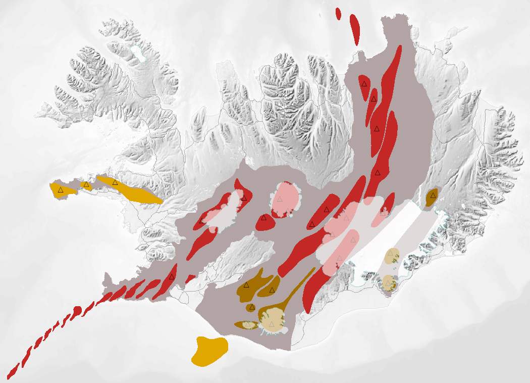
NI_J600v Bergraðir Íslands – 1:600.000
Gagnasafn (GDB) NI_J600v_bergradir_ISN93_1.utg:
NI_J600v Bergraðir Íslands – 1:600.000 [NI_J600v Igneous rock series of Iceland – 1:600.000].
Kort af þremur bergröðum Íslands. Kortið sýnir virk gosbelti á Íslandi og landgrunni þess á nútíma og síðjökultíma, virk eldstöðvakerfi á nútíma, útbreiðslu gosstöðva og samsetningu gosbergs (flákalag). Staðsetning megineldstöðva er einnig sýnd (punktalag). Gerður er greinarmunur á þóleiískum, alkalískum og millibergskerfum.
[The map of the three igneous rock series of Iceland at a scale of 1:600.000 shows the volcanic zones active in Iceland and its insular shelf during the Holocene and Late Pleistocene, volcanic systems active during the Holocene, the distribution of eruption sites and chemical composition of erupted rocks (polygon layer). The position of central volcanoes is also shown (point layer). Tholeiitic, alkalic and transitional alkalic volcanic systems are differentiated.]
Simple
- Date ( Publication )
- 2022-01-12
- Identifier
- {7C7C80FC-4C63-4384-A3C9-F4580A298EB6}
- Status
- On going
- Keywords ( Theme )
-
- INSPIRE
- Jarðeðlisfræði
- Geoscientific information
- Jarðfræði
- Geology
- Náttúruleg áhættusvæði
- Natural risk zones
- GEMET - INSPIRE themes, version 1.0 ( Theme )
- GSL flokkun ( Theme )
- Topic categories in accordance with EN ISO 19115 ( Theme )
-
- Geoscientific Information
- Use constraints
- Other restrictions
- Other constraints
-
https://www.natt.is/is/midlun/opin-gogn
Gögnin eru öllum opin – no limitations on public access
- Access constraints
- Other restrictions
- Other constraints
- no limitations to public access
- Spatial representation type
- Vector
- Denominator
- 600000
- Metadata language
- is
- Topic category
-
- Geoscientific information
))
- Begin date
- 2008-01-01
- End date
- 2008-01-01
- Reference system identifier
- EPSG / 3057
- Distribution format
-
-
ESRI Shapefile
(
10.2.0.3389
)
-
ESRI ArcGIS FileGDB
(
10.2.0.3389
)
-
ESRI Shapefile
(
10.2.0.3389
)
- OnLine resource
- Niðurhal gagna ( WWW:LINK-1.0-http--link )
- OnLine resource
- Vefur Náttúrufræðistofnunar ( WWW:LINK-1.0-http--link )
- OnLine resource
- Fitjuskrá 600 Jarðmyndun og landmótun (PDF) ( WWW:LINK-1.0-http--link )
- OnLine resource
- Vefur Náttúrufræðistofnunar: Eldstöðvakerfi ( WWW:LINK-1.0-http--link )
- OnLine resource
- Skilmálar (PDF) - Licence (PDF) ( WWW:LINK-1.0-http--link )
- OnLine resource
- NÁTT kortasjá ´Jarðfræði Íslands´ ( WWW:LINK-1.0-http--link )
- Hierarchy level
- Dataset
Conformance result
- Date ( Publication )
- 2010-12-08
- Explanation
- Information required according to INSPIRE Geoportal Validator´s verification report. Validation has not been performed.
- Pass
- Yes
- Statement
-
Höfundur kortsins er Sveinn P. Jakobsson. Kortið birtist í: Sveinn P. Jakobsson, Kristján Jónasson og Ingvar A. Sigurðsson 2008.
The three igneous rock series of Iceland. Jökull 58: 117–138. Nöfnum nokkurra eldstöðva hefur verið breytt til samræmis við Íslenska eldfjallavefsjá ( https://icelandicvolcanos.is/ ).
Gögnin eru uppfærð eftir þörfum.
[The author of the map is Sveinn P. Jakobsson. It appears in Sveinn P. Jakobsson, Kristján Jónasson and Ingvar A. Sigurðsson 2008. The three igneous rock series of Iceland. Jökull 58: 117–138.
Names of some volcanic systems and central volcanoes have been changed in accordance with the 'Catalogue of Icelandic Volcanoes' ( https://icelandicvolcanos.is/ ).]
gmd:MD_Metadata
- File identifier
- b108ddc6-bdc5-4c7e-8e98-204e5c843622 XML
- Metadata language
- en
- Hierarchy level
- Dataset
- Date stamp
- 2025-08-08T13:49:48
- Metadata standard name
- INSPIRE Metadata Implementing Rules
- Metadata standard version
- Technical Guidelines based on EN ISO 19115 and EN ISO 19119 (Version 1.2)
Overviews
Spatial extent
Provided by
