Lýsigagnagátt
Hallakort fyrir upptakasvæði snjóflóða - xyz þjónusta
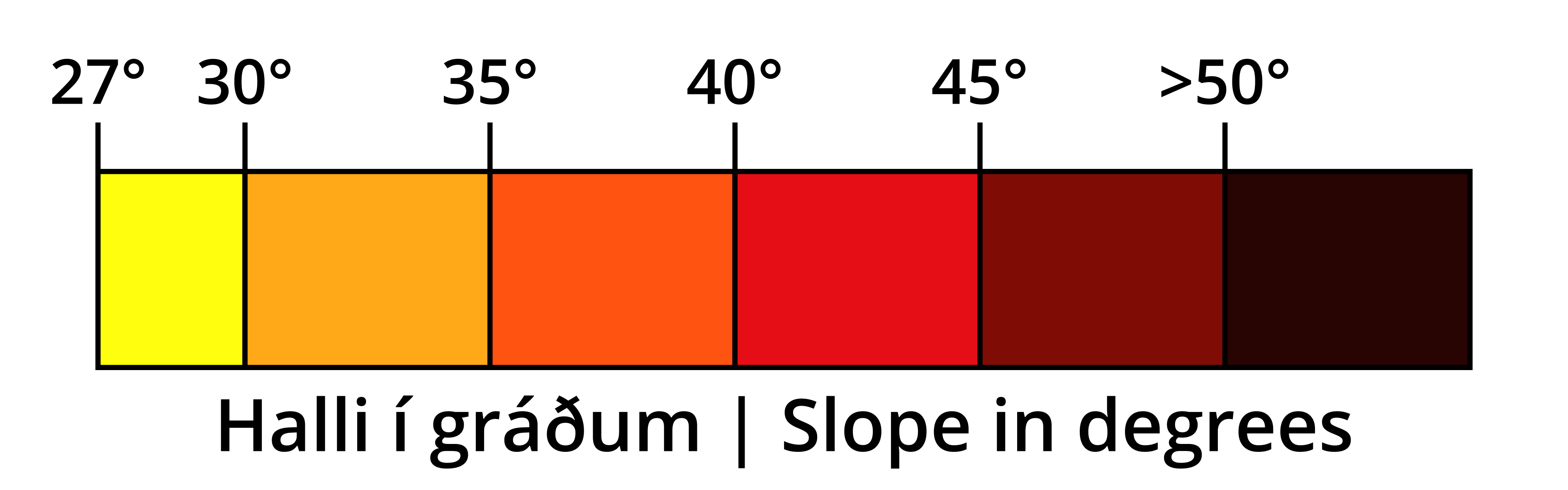
Þekja sem sýnir halla lands í gráðum byggt á landlíkani Náttúrufræðistofnunar (IslandsDEM útg. 1). Aðeins er sýndur halli á ákveðnu bili sem miðast við algengan upptakahalla snjóflóða. Litir og flokkun halla er ætluð til að hjálpa ferðafólki í fjalllendi að meta halla í brekkum með tilliti til upptakahalla snjóflóða. Þekjuna er hægt að birta sem myndkorta-flísar (XYZ, 512x512 pixlar) í Web-Mercator vörpun (EPSG:3857).
Sniðmát fyrir slóðina á flísarnar eru: https://geo.vedur.is/geoserver/www/imo_slopemap_epsg3857_v1/{z}/{x}/{y}.png
Skýringarmynd fyrir litakvarða er aðgengileg hér: https://geo.vedur.is/geoserver/www/imo_slopemap_epsg3857_v1/Legend_box_v1.png
Simple
- Date (Publication)
- 2023-05-02T00:00:00
- Citation identifier
- https://gatt.lmi.is/geonetwork/srv/resourcesa3337b9f-6202-4c00-8022-e67bad81cd7b
- Point of contact
-
Organisation name Individual name Electronic mail address Role Veðurstofa Íslands
Owner
- Keywords
-
-
landhalli
-
snjóflóð
-
upptakahalli
-
opin gögn
-
GSL
-
INSPIRE
-
myndflísar
-
xyz
-
- Use constraints
- Other restrictions
- Other constraints
- no limitations to public access
- Access constraints
- Other restrictions
- Other constraints
- Attribution 4.0 International (CC BY 4.0)
- Service Type
- view
))
- Coupling Type
- Tight
- Contains Operations
-
Operation Name Distributed Computing Platforms Connect Point GetCapabilities
Web services https://geo.vedur.is/geoserver/wms?&REQUEST=GetCapabilities
- Reference system identifier
- http://www.opengis.net/def/crs/EPSG/0/3057
- Distribution format
-
Name Version PNG
Digital transfer options
- OnLine resource
-
Protocol Linkage Name WWW:LINK-1.0-http--link
https://geo.vedur.is/geoserver/www/imo_slopemap_epsg3857_v1/{z}/{x}/{y}.png Hallakort fyrir upptakasvæði snjóflóða
WWW:LINK-1.0-http--link
https://geo.vedur.is/geoserver/www/imo_slopemap_epsg3857_v1/Legend_box_v1.png Skýringarmynd með litakvarða.
- Hierarchy level
- Service
- Other
-
Service
Conformance result
- Date (Publication)
- 2009-10-19
- Explanation
-
This service is not conformant with the INSPIRE Implementing Rules for Network Services.
- Pass
- No
Conformance result
- Title
-
Data Specification on Administrative Units – Technical Guidelines
- Date (Publication)
- 2014-04-17
- Explanation
-
See the referenced specification
- Pass
- No
- Statement
-
Halli reiknaður út frá landlíkani Náttúrufræðistofnun, IslandsDEM útg. 1.
Metadata
- File identifier
- b39b190d-633a-40e9-ab5f-9753dee5b51a XML
- Metadata language
- English
- Character set
- UTF8
- Hierarchy level
- Service
- Hierarchy level name
-
Service
- Date stamp
- 2026-10-27T08:25:16.947417611Z
- Metadata standard name
-
ISO 19115:2003/19139
- Metadata standard version
-
1.0
- Metadata author
-
Organisation name Individual name Electronic mail address Role Veðurstofa Íslands
Ragnar Heiðar Þrastarson
Point of contact